

All the maps that’s fit to pin.
CURRENT RAIL SYSTEM AND ROUTE MAPS AND SCHEDULES, FROM MASSACHUSETTS TO CONNECTICUT TO NEW YORK TO NEW JERSEY TO SOUTHEASTERN PENNSYLVANIA TO DELAWARE TO MARYLAND TO WASHINGTON, D.C. TO NORTHERN VIRGINIA.

In the past year my wife and I spent planning our move to the northeast from Florida, I really only had one “must-have”—that we live within walking distance to a train station into New York City. Outside of that, I could sleep in a bathtub on a roof (she did require the roof be over our heads).
Over several months I collected, printed, and pinned maps from regional and interstate rail systems to a cork board, sorting pins and timing out schedules.
We looked at a few dozen cities, seriously at Suffern, NY, Beacon, NY, Newburgh, NY, Peekskill, NY, Yonkers, NY, and Secaucus, NJ, before settling on Jersey City, NJ—a 12-minute walk to West Side Station on the Hudson-Bergen Light Rail, connecting to the city via PATH at Exchange Place and Newport.

I had emailed a professor with a planning question once, and she responded that she would answer in class, explaining that: “If one student has a question, other students likely have that question as well.”
This may have been her way of avoiding me. It was still an important insight.
I thought maybe others would benefit from having access to the all of the maps I collected, in one place—so here are all of the public rail system route maps and schedules that will help you plan travel from Haverhill, MA to Spotsylvania, VA, and everywhere in between and all around.
Images are system maps. Underlined route names link to schedule PDFs which open in a new window.
From north to south:
MASSACHUSETTS BAY TRANSPORTATION AUTHORITY
Commuter Rail Map

ROUTE SCHEDULES: [Fairmount] [Fitchburg] [Greenbush] [Haverhill] [Kingston] [Needham] [Middleborough-Kingston-Greenbush-Braintree-South Station] [Newburyport-Rockport ] [ Worcester] [Franklin]. [Providence] [Lowell] [Commuter rail system map]
MASSACHUSETTS BAY TRANSPORTATION AUTHORITY
Rapid Transit/Key Bus Routes system map

ROUTE SCHEDULES: [Rapid Transit/Key Bus Routes system map/combined schedules]
CTrail
Hartford Line with Connecting Services / system map

METROPOLITAN TRANSPORTATION AUTHORITY (MTA)
New York City Subway system map

METROPOLITAN TRANSPORTATION AUTHORITY (MTA)
New York City Subway system map (pilot)

METROPOLITAN TRANSPORTATION AUTHORITY (MTA)
Metro-North Railroad system map

ROUTE SCHEDULES: [Port Jervis] [Pascack Valley] [Hudson] [Harlem] [New Haven] [Metro-North Railroad system map]
METROPOLITAN TRANSPORTATION AUTHORITY (MTA)
Long Island Rail Road system map

ROUTE SCHEDULES: [Babylon] [City Terminal-Atlantic Terminal ] [City Terminal-Manhattan] [Far Rockaway] [Hempstead] [Long Beach] [Montauk] [Oyster Bay] [Port Jefferson] [Port Washington] [Ronkonkoma] [West Hempstead] [Long Island Rail Road system map]
PORT AUTHORITY OF NEW YORK AND NEW JERSEY
PATH (Port Authority Trans-Hudson) Train

NJ TRANSIT
System map (current)
ROUTE SCHEDULES: [Atlantic City] [Main-Bergen] [Montclair-Boonton] [Morrison-Essex] [North Jersey Coast] [Northeast Corridor] [Pascack Valley] [Raritan Valley] [NJ Transit rail system map]
NJ TRANSIT
System map (legacy)
NJ TRANSIT
Light Rail

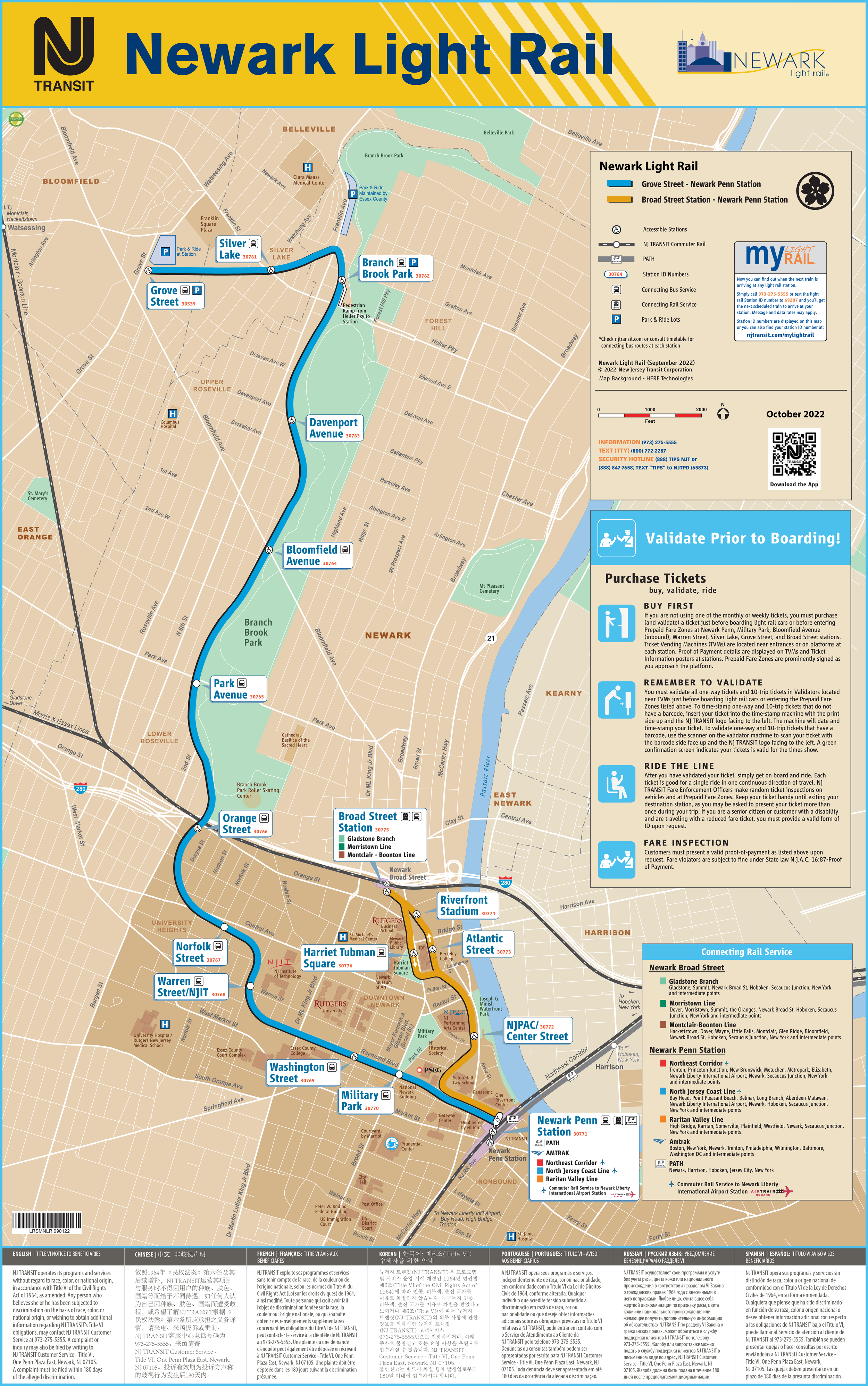

ROUTE SCHEDULES: [Hudson-Bergen] [Newark] [River Line]
PORT AUTHORITY TRANSIT CORPORATION
PATCO

SOUTHEASTERN PENNSYLVANIA TRANSPORTATION AUTHORITY (SEPTA)
Regional Rail & Rail Transit

ROUTE SCHEDULES: [Airport] [Chestnut Hill East] [Chestnut Hill West] [Cynwyd] [Fox Chase] [Lansdale/Doylestown] [Media/Wawa] [Manayunk/Norristown] [Paoli/Thorndale] [Penn Medicine Station/Center City] [Philadelphia (combined)] [Trenton] [ Warminster] [ Wilmington/Newark] [West Trenton] [Regional Rail & Rail Transit system map]
SOUTHEASTERN PENNSYLVANIA TRANSPORTATION AUTHORITY (SEPTA)
Metro–subway/elevated


ROUTE SCHEDULES: [Broad Street] [Market Frankford] [Norristown High Speed]
SOUTHEASTERN PENNSYLVANIA TRANSPORTATION AUTHORITY (SEPTA)
Metro–trolley


ROUTE SCHEDULES: [10] [11] [13] [15 ] [ 34] [36] [101] [102] [Routes 10, 11, 13, 15, 34, 36 map] [Routes 101 & 102 map]
WASHINGTON METROPOLITAN AREA TRANSIT AUTHORITY (WMATA)
Metrorail

MARYLAND TRANSIT ADMINISTRATION (MTA)
Maryland Area Rail Commuter (MARC) system map

ROUTE SCHEDULES: [Brunswick ] [Camden] [Penn] [Light Rail Link] [MARC system map ]
VIRGINIA RAILWAY EXPRESS (VRE)
System map

ROUTE SCHEDULES: Fredericksburg |. Manassas. [VRE system map]